|
|
|
| Watershed Show | |
|
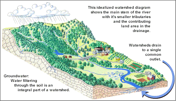
THE WATER CYCLE The most critical part of our life's existence is the clean water we drink, use and enjoy on a daily basis. Water within a watershed is connected and recycled through a process called the water cycle. The water or hydrologic cycle represents the constant movement of water from the earth's surface infiltrating through the soil into the groundwater, resurfacing to streams, and evaporating in the atmosphere and back again. In the process, water becomes a force of change as it erodes and carries various materials along with it. Pollution can enter this water movement at any stage of the water cycle through many routes including air pollution, surface runoff, or groundwater contamination. In Rajasthan watersheds, water pollution commonly takes the form of sedimentation from soil erosion, septic tank leachate, lawn fertilizers and pesticides, road salt, motor oil and other petroleum products and stormwater runoff. Any one of these many different sources of contamination can, by itself, be a threat to water quality within the watershed. However, the cumulative effect of different sources of contamination, also know as non-point source pollution, can have a much greater negative impact on surface or groundwater (drinking water) supplies within a watershed. Protection and prevention of water resources prior to contamination is always less expensive than cleanup after pollution has entered the cycle. The key to protecting water quality begins with a basic understanding of the water cycle and a watershed. A watershed is a geographic area of land across which water, and the sediments and dissolved materials it contains, flow on their A watershed can be compared to a huge basin collecting all the precipitation that falls within it and carrying this to the common outlet. A watershed includes not only the land within its boundaries but also the surface water of lakes, streams and wetlands as well as the groundwater moving beneath the surface. Watersheds vary from the largest river basins to just a few acres in size. Watersheds are natural systems that link the land and water resources and the living organisms, including people, within its boundaries. How we live on the land affects the quality and quantity of water resources within the watershed. GROUNDWATER Groundwater is water at one stage of the water (hydrologic) cycle. The water in the cycle which filters through the soil and is not taken in by plants (and then transpired into the atmosphere) becomes groundwater. Water filtering through the soil moves first through an unsaturated zone where spaces (pores) between soil particles or rocks contain both air and water. The water is pulled by gravity in a generally downward path and eventually reaches an area of soil and rock where the spaces (pores) are completely filled with water. This is called the saturated zone or "groundwater." The top of this zone of saturation is called the water table. Groundwater, like surface water, is constantly moving. However, groundwater moves much slower - at rates ranging from feet per day to inches per year depending on the type of soil and rock through which it is moving. The natural movement of groundwater is from upland recharge areas to lowland discharge areas. Discharge areas are areas where the water table meets the land surface such as springs, lakes, streams, wetlands. Most water seeping into the soil moves only a few miles to the point where it is discharged; in most instances it stays within the same watershed. Groundwater discharging into streams provides the water which keeps streams flowing year round and particularly in drought periods. Except for a short time during and after rain storms and snow melt, all the water in a stream is provided by groundwater seeping through stream banks and stream beds. This is called base flow. Surface Water Water in the cycle which falls as precipitation and which does not infiltrate back into the soil and eventually become part of the groundwater table runs across the surface of the land. This water flows into surface water catchments called lakes, streams, and wetlands. |
|
 |
Hydrologic Cycle The hydrologic, or water, cycle is the continuous, interlinked circulation of water among its various compartments in the environment. Hydrologic budgets are analyses of the quantities of water stored, and the rates of transfer into and out of those various compartments. A simplified hydrologic cycle starts with heating caused by solar energy and progresses through stages of evaporation (or sublimation), condensation, precipitation (snow, rain, hail, glaze), groundwater, and runoff. The most important places in which water occurs are the oceans, glaciers, underground aquifers, surface waters, and the atmosphere. The total amount of water among all of these compartments is a fixed, global quantity. However, water moves readily among its various compartments through the processes of evaporation, precipitation, and surface and subsurface flows. Each of these compartments receives inputs of water and has corresponding outputs, representing a flow-through system. If there are imbalances between inputs and outputs, there can be significant changes in the quantities stored locally or even globally. An example of a local change is the drought that can occur in soil after a long period without replenishment by precipitation. An example of a global change in hydrology is the increasing mass of continental ice that occurs during glacial epochs, an event that can remove so much water from the oceanic compartment that sea level can decline by more than 328 ft (100 m), exposing vast areas of continental shelf for the development of terrestrial ecosystems. Estimates have been made of the quantities of water that are stored in various global compartments. By far, the largest quantity of water occurs in the deep lithosphere, which contains an estimated 27×1018 tons (27-billion-billion tons) of water, or 94.7% of the global total. The next largest compartment is the oceans, which contain 1.5×10¹⁸ tons, or 5.2% of the total. Ice caps contain 0.019×10¹⁸ tons, equivalent to most of the remaining 0.1% of Earth's water. Although present in relatively small quantities compared to the above, water in other compartments is very important ecologically because it is present in places where biological processes occur. These include shallow groundwater (2.7×10¹⁴ tons), inland surface waters such as lakes and rivers (0.27×10¹⁴ ton), and the atmosphere (0.14×10¹⁴ tons).
|
Watershed is a geo-hydrological unit comprised of all land and water within the confines of a drainage divide. Essentially a watershed is all the land and water area which contributes runoff to a common point. It is a land area that captures rainfall and conveys the overland flow and runoff to an outlet in the main flow channel. It is a topographically delineated area draining into a single channel. A watershed may be nearly flat or may include hillocks, hills or mountains. Each and every water and land area is a part of one watershed or other. Frequently the following distinction is being made to indicate the size of a watershed: micro watershed, sub watershed, watershed, catchment and river basin in order of increasing size. Generally any watershed can be sub-divided into sub-watersheds etc. The smallest watershed in the context of agricultural hydrology may be the field or plot. Further more within the context of watershed management, watershed may be defined as the ecosystem within the confirms of a drainage divide. Watershed management is defined as the integrated use, regulation and development of water and land resources of a watershed to accomplish sustainable use of land, water and vegetables. The emphasis is on soil and water conservation. Why is watershed Management needed? As 70% of our cultivated land fall under the rain-fed areas, Watershed Management is one of the critical factors for improving agricultural production. The natural resource base on which existence of living beings depend-soil, water and vegetation is under degradation. Most of the arid and semi-arid regions have concentrations of eroded and degraded natural resources. Loss of vegetal cover, followed by soil degradation through erosion, has resulted in lands lacking in water as well as solid nutrients. In Watershed Development Programmes in India Conservation of raw water and checking soil erosion is central to the attainment of economic as well as financial sustainability of dry land and agriculture. Integrated watershed development programme is the major policy instrument for achieving this goal. The importance of watershed development as a strategy of agricultural and overall rural development in rainfed areas has been recognized in Some of the points of development to be kept in mind are : Ø Growth of yield among irrigated crops and regions attained during the initial phase of the green revolution has come to some kind of a halt. Hence the future growth of agricultural production will have to increasingly come from dryland region at least till another flux of large scale investment in irrigation takes place. Ø Frequent future of rainfall especially since 1980's has resulted into highly fluctuating productivity in dryland region making at difficult to sustain the population on farming system alone. Ø The immediate solution of tapping groundwater has also reached alarming levels of depletion in many parts of the dryland region. Ø With increasing human and livestock population with the uncertain crop yield has reduced availability of the common property resources (CPRs) and the bio-mass. Ø Formation of Integrated Watershed Development (WSD) programmes esp. since mid 1980's is manifesting such realisation. The main ethos of integrated approach are : Ø Simultaneous development of land and biomass resources in the light of symbiotic relationship among them. Ø Integrated farming system approach. Ø Meeting food, fodder and fuel requirement of human and livestock population depend on these resources. Ø Ensuring environmental sustainability along with economic viability by promoting cost technologies. Ø Improving land productivity by promoting better agronomic practices. Ø Realising population pressure on land, creating non-farm employment. Ø Development of local institution for future management through participating approach. Predominant Occupation In Importance has been given to dry farming in The main objective of the programme are : Ø To increase the yield from land by adopting soil and water conservation technologies. Ø To construct small water storage ponds, streams, checkdams and thereby increasing the underground water table. Ø To promote environmental balance with financial aid in 1984 from the world bank. Ø Karnataka has successfully implemented one watershed project, mainly Kabbalana Watershed Project in Bangalore Rural District during 1984. Conclusion A watershed, synonymous with catchment or basin, is made up of the natural resources in a basin esp. the water, soild and vegetative factors. The compressive development of a basin as to make productive use of all its natural resources and also protect them is termed watershed management. This includes land improvements, rehabilitation and other technical work as well as the human consideration. The watershed management essentially involved the following principles : Ø Land and water resources are interactive ports of natural ecosystem and should be managed as catchment basic. Ø Catchments are continually changing and need to be managed by considering these changes. Ø Management of land and water resources must be coordinated, with decision based on the best available information. Ø Sound land and water management is best achieved through the information action of individual users and managers of these resources. Ø A balance of economic development and conservation of land and water resources must be maintained. |
|
 |
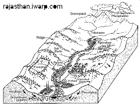
Concept Line Diagram of a watershed
|
|
|
|
I've always loved this waterfall! You can see ones just like it near my house, just a couple of miles away! |
|
|
|
|
|
|
|